Tag Archives: Historic Urban Landscape

Detective Work by the Yarrowee

Have you ever wondered where the sites of famous paintings are actually located? This curiosity and the iconic Warrenheip Hills near Ballarat painted by Eugene von Guérard have led intrepid FedUni postgraduate researcher George Hook to make some fascinating discoveries. George tells his story here.

George Hook

My thesis focuses on fidelity to nature issues in the paintings of leading nineteenth century Australian landscape painter Eugene von Guérard. In particular, I am interested in composite landscapes in which two field sketches are combined to form an artwork that communicates the essential nature of, or a narrative about, a specific environment.

In the National Gallery of Victoria hangs an iconic painting entitled Warrenheip Hills near Ballarat. As this important artwork is his first major Australian landscape painting it has received quite a lot of attention from art historians, von Guérard aficionados and locals, but rather puzzlingly the peak doesn’t look much like Mount Warrenheip nor has the idyllic rocky pool been located. My take on the painting was that most likely it is a composite work and the vantage point of the main source sketch might possibly be located if the painted shape of Mt. Warrenheip was ignored.

warrenheip-hills-near-ballarat-1854 (

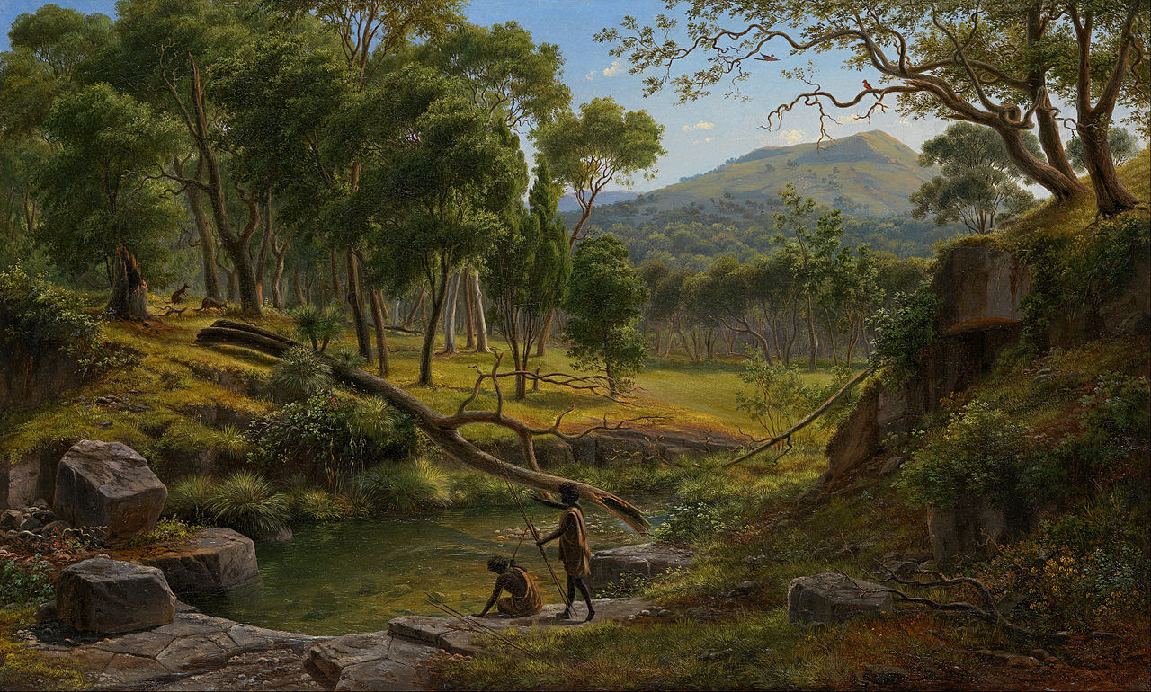
Eugene von Guérard: Warrenheip Hills near Ballarat 1854, National Gallery of Victoria.

My starting point was the artist’s large drawing in the State Library of Victoria. Assuming the distant hilltop visible between the trees is meant to be Mt. Warrenheip and the rocky pool is part of a creek flowing away from the viewer, then the trick would be to find a site somewhere along the Yarrowee River whose topography and hydrology matched that illustrated, with a view to Mt. Warrenheip thrown in. This proved easier said than done, especially given how extensively the Yarrowee River has been modified by miners, farmers, urban planners and the water board.

Warreneep Hills bei Ballarat, 1854 (SLV)

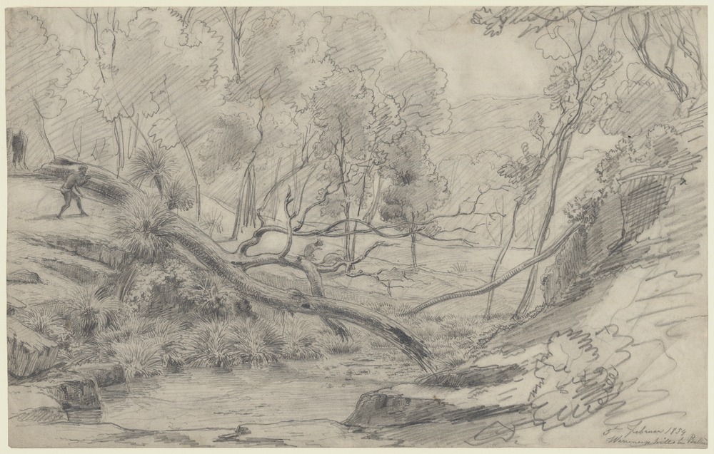
Eugene von Guérard: Warreneep hills bei Ballarat, 5th Februar 1854, State Library of Victoria.

More critical to locating the site were geological clues embedded in the drawing and painting, and here von Guérard had me fooled completely at times. In the drawing, the rocks forming the front edge of the pool are irregularly shaped but with a level top surface. Those in the painting have the polygonal shapes of tessellated basalt pavement, which is the top surface of highly regular columns of basalt lava.

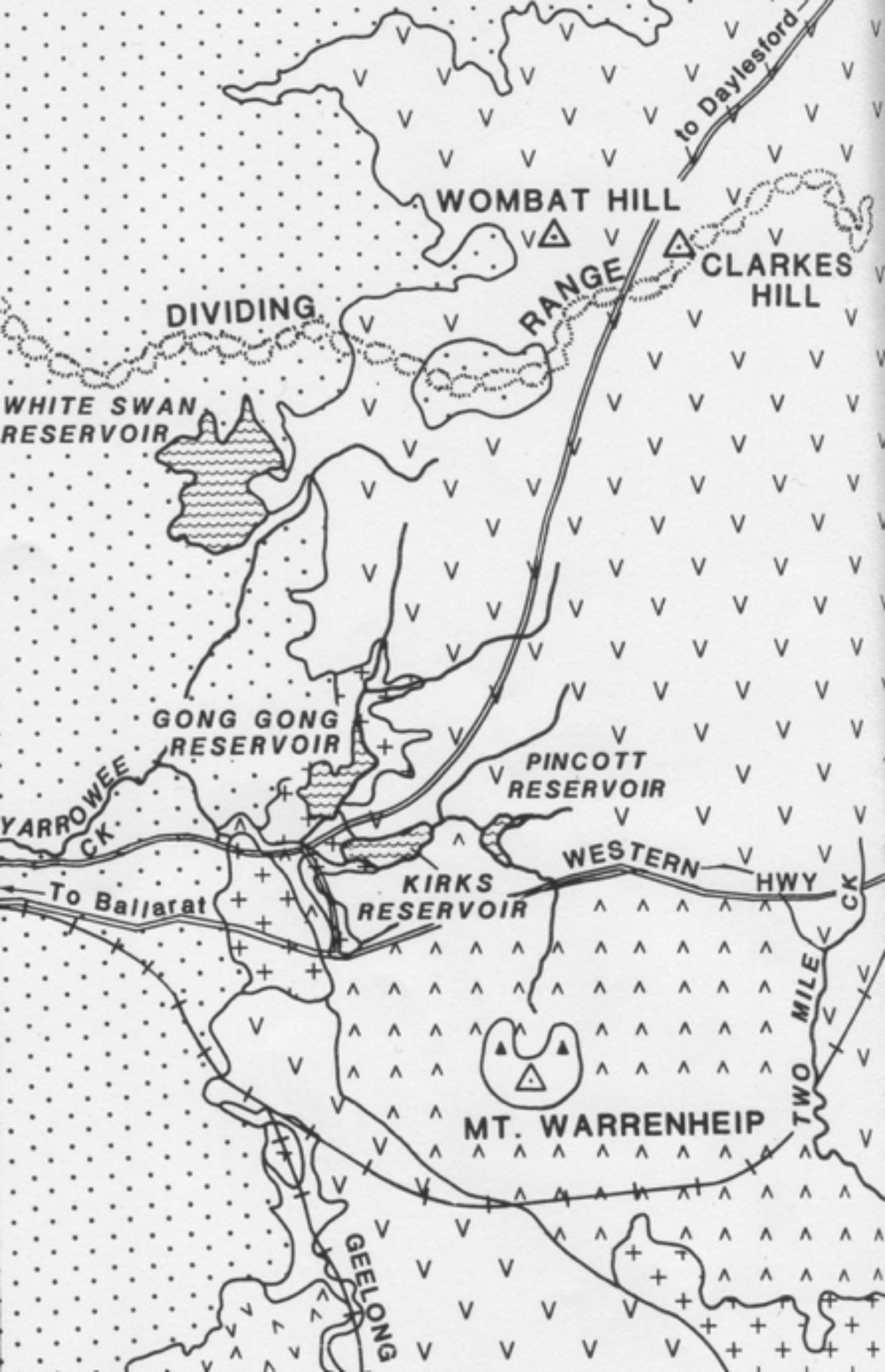
My initial speculation about the geology was that the pool ledge could be a section of the front edge of a basalt lava flow from Clarkes Hill to the north, which has been gradually worn back by the tumbling action of water over geological time, but a misunderstood email from Federation University geologist Stephen Carey seemed to indicate there was no columnar basalt around Kirks or Pincott reservoirs, so I never bothered checking my initial conjecture.

PastedGraphic-1.jpg

Lava flows and scoria cones east of Ballarat (detail from Figure 12-2.4 in Ian Clark, Barry Cook and Greg Cochrane, Victorian Geology Excursion Guide, Canberra, 1988, p. 202).

The blocky looking rocks forming the left bank above the pool in the drawing and painting are an intriguing feature as they don’t look much like basalt or even granite. David Taylor from the Geological Survey of Victoria thought they resembled vertically cleaved sandstone found only in the hinge of a fold. Due to tectonic forces in Earth’s crust, the sandstone bedrock underlying much of Ballarat has been crumpled into large folds running in a north-south direction. As fold hinges are usually only a few meters wide, they are relatively rare. If David’s insight was correct, then the key to locating the site would be to find where the Yarrowee cuts a hinge, matches the general topography of the drawing, and provides a view of Mt Warrenheip if taller trees were removed.

Tony Mander Geology of folds in the Ballarat district

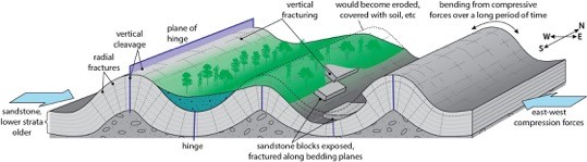
Tony Mander: Geology of folds in the Ballarat district.

Over a period of nine months, I investigated three sites along the Yarrowee and two on sandstone elsewhere, along the way acquiring some skill in using a machete and a geological hammer. I located two possible sites that met the above criteria, although one rather disconcertingly faced Blackhill rather than Mt. Warrenheip, but frustratingly neither Stephen nor David could find conclusive evidence of that elusive hinge at either site.

Over a somewhat subdued pub lunch at the Brownhill Tavern adjacent to one of my hopeful sites, I showed David a copy of the painting without realising that he had only ever looked at the drawing previously. He immediately picked up on the tessellated pavement and said there was columnar basalt in the catchment area east of the Ballarat-Daylesford Road. The next week I contacted Peter Field of Central Highlands Water, who gave permission to enter the catchment area between Kirks and Pincotts reservoirs. From topographic and geological maps, I worked out where the rocky pool ought to be if it still existed, and set out to walk from Kirks along the then dry creek bed to Pincotts, but the head-high blackberry proved impossible to penetrate, so I followed a logging track up to Pincotts and began to walk back down the creek.

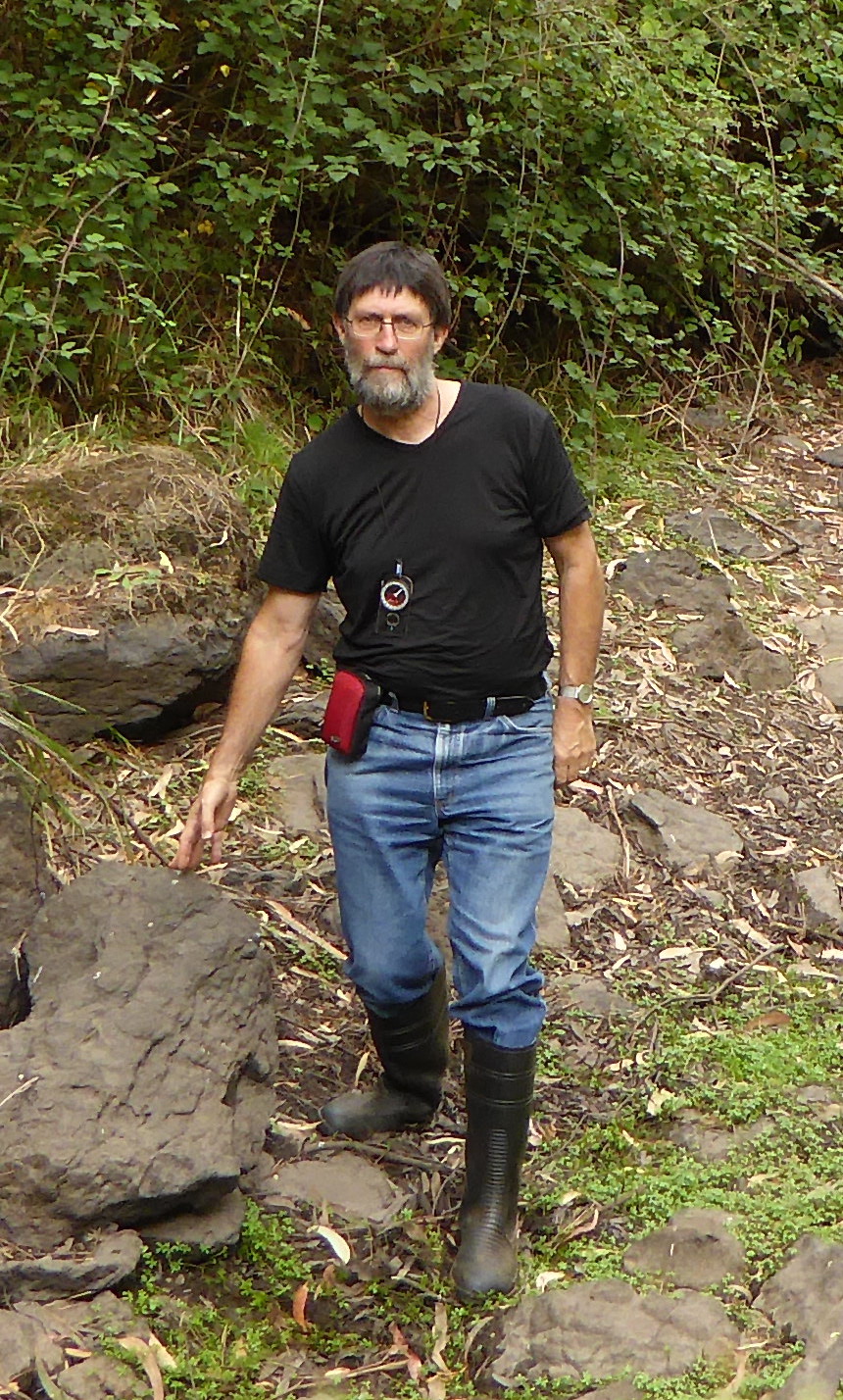
Within minutes I stumbled across a rocky stream depression that matched so many of the topographical, hydrological and geological features in von Guerard’s drawing that I was immediately convinced I had found that site where he stood to make the sketch on which the famous painting is based. It was a thrilling moment realising that only he and I knew exactly where he had been sketching on the afternoon of the 5th of February 1854.

Site of the field drawing

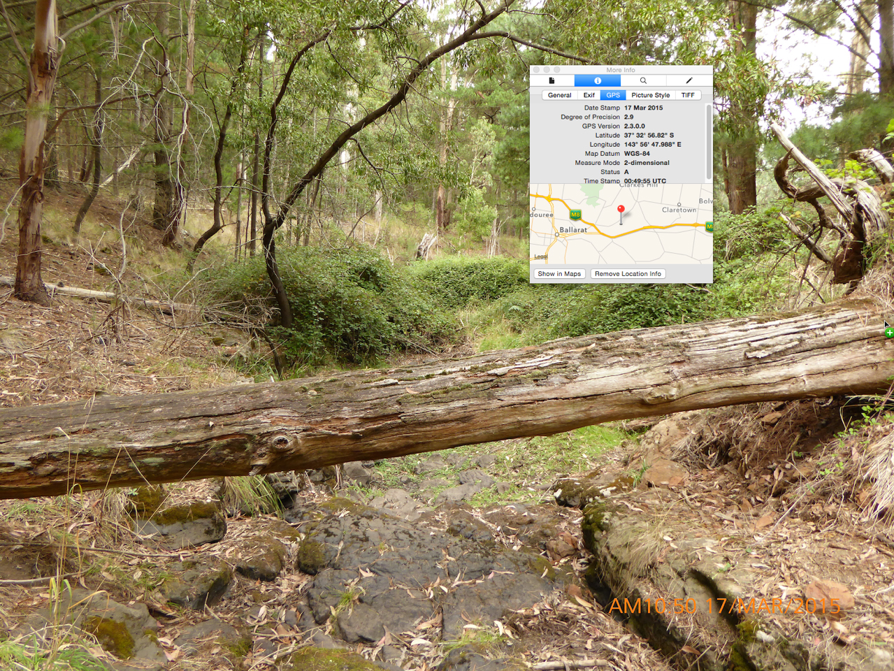
Site of the field drawing along the Yarrowee River

The rocky ledge just visible beneath the fallen tree trunk in the photo is indeed a knickpoint in a section of a columnar basalt lava flow, which has been steadily retreating upstream over the last three million years as tumbling water undermines the base of the ledge. The columns, however, are very irregular in shape so his tessellations must be attributed to artistic licence.

Since then I have taken several art historians to the site, or shown them photographic evidence, and all agree the evidence is strong, even compelling. Gordon Morrison, director of the Ballarat Art Gallery, said he would only be fully convinced if Mt. Warrenheip could be seen in the distance, so I enlisted the help of local photographer Andrew Thomas to fly his drone camera above the trees surrounding the now water-filled pool and below you can see the evidence that finally convinced him.

View of Mt. Warrenheip by Andrew Thomas

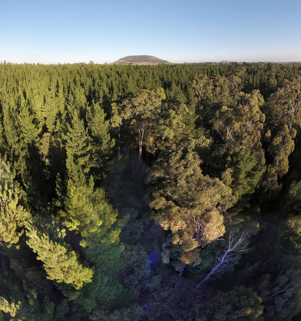
Andrew Thomas: View of Mt. Warrenheip from above von Guérard’s site when the pool was filled with water on 17 May 2015. (The fallen log can just be seen at the bottom middle. )

George Hook

August 2015

Stories Bringing New Perspectives

This is the first in a series of blog posts exploring stories of research, looking at what the historic urban landscape might mean for different research and storytelling projects.

Lucinda Horrocks is one half of Wind & Sky Productions, a Ballarat based independent film production company specialising in short form documentaries, and she joins us here for a Q&A.

The key concept behind the Historic Urban Landscape (HUL) and Visualising Ballarat portals is to provide different lenses with which to view the city and region. As storytellers, Wind & Sky explore ways of presenting multiple perspectives in compelling “big ideas for the small screen.”

You have worked on/are working on a couple of interesting historical projects connected to Federation University Australia- can you talk a bit about Seeing the Land from an Aboriginal Canoe and Memories of War? And how have the processes differed?

‘Seeing the Land from an Aboriginal Canoe’ is a film and multimedia project about a forgotten history of encounters between Aboriginal Victorians and settlers on the rivers of Victoria in the 1800s. The FedUni connection is that the project was inspired by the research of Associate Professor Fred Cahir, who was struck by the everyday use of bark canoes in Victoria in the 19th century, and the reliance European settlers had on Aboriginal technology and skills in that period. The project, which is hosted on Culture Victoria, features interviews with Fred Cahir and Traditional Owners Uncle Bryon Powell, Jamie Lowe and Rick Nelson, and includes artwork, maps and photographs from the regional and metropolitan collections of the State Library of Victoria, the Art Gallery of Ballarat, Public Record Office Victoria, Museum Victoria and the Ballarat Gold Museum. More here.

‘Memories of War’ is a collaborative project now in progress between Wind & Sky, Ballarat RSL, FedUni, the Gold Museum and M.A.D.E Ballarat. It commemorates the centenary of WW1 in Ballarat by exploring the connections young Ballarat people today have to events that took place a hundred years ago. A number of writing, history, arts and education students at FedUni have gone through a process of understanding WW1 this year and they are going to share their stories on a specially developed blog run by the Ballarat Gold Museum. We at Wind & Sky are producing a documentary film about the student journey and that is going to be shown at M.A.D.E Ballarat in a special screening and Q&A event on the 8 November. More info at: http://mow.windsky.com.au/

Alisha Eddy (FU) Nick Murohy (FU)

Alisha Eddy and Nick Murphy, actors from Federation University taking part in the Memories of War film project

I suppose the subject matter for each project is different, but for each project we are trying to work through a process of discovering the heart of a story behind the bare facts of history. With the canoe project that involved working closely with Fred to identify core stories but also required reaching out to Aboriginal communities to try and understand what that history means in today’s context. And that took a lot of time and listening. It’s a very subtle thing creating a documentary, it’s very collaborative, you try to let people speak for themselves, yet provide some framework and structure so it all ties together into a narrative. There’s a lot of work in getting it right, and we don’t always get it right. The ‘Memories of War’ project is complicated by the uncertain nature of it – we’re not sure how many students will choose to participate in the blog project, we’re not sure what we’re going to get. But then we’re never sure what we’re going to get in the end. That’s what makes it an exploration rather than an exposition.

What does the historic urban landscape mean to you in projects like these?

This is a tough question to answer. I’m not sure I know what historic urban landscape means. Places change over time and often the landscape that we cherish today as historical doesn’t actually relate that well to the historical story we cherish. And what does urban mean when you are talking about places of history? What is a city now wasn’t always. Look at the landscape of the 1850s and the Eureka Stockade for example – it must have been a big riotous tent city in a devastated and dug up environment. It was probably quite ugly and not much to do with the urban environment we see today or even the grand buildings of Ballarat we think of as iconic.  Urbanisation is an overlay that can add interest and diversity to a place but also threaten older landscapes and buildings. Cities are constantly rewriting their landscape and rewriting their histories. It’s an incredibly complex thing. Sometimes we play around with this complexity in our films.

With the canoe project we went to some very specific locations which were significant for the stories Fred had unearthed and for the traditional owners who spoke about them. Some were urban and some weren’t. For example we interviewed Uncle Bryon Powell, Wadawurrung Elder, on the banks of the Barwon River in the centre of Geelong, which is now very built up and vastly different from the story of what that place was like in the 1800s. But that for us was an interesting juxtaposition, to sit on that genteel river edge where they have ‘Henley on the Barwon’ today and imagine another landscape where the banks were lined with River Red Gums and Wadawurrung people relied on the resources of the river and the forest and interacted with explorers and squatters, and each group wanted to manage that landscape differently.

Bryon Powell FedSquare---Fred-Cahir

Uncle Bryon Powell by the Barwon River and Professor Fred Cahir on screen at Federation Square

How do you think the stories and memories of a city connect to the physical landscape?

Can a city have a memory? That’s an interesting question. So many people pass through cities at different times and there are a multitude of memories and stories and perspectives about them, some ancient, some recent, some dark and uncomfortable, most of them unknown, some celebrated, many of them historically wrong.  I think places with stories are powerful. Look at the Pyramids or Stonehenge. They are powerful because of what they are, but also because writers have written about them for centuries and we know, or think we know, their story. Look at Hanging Rock. It’s a beautiful place but made so much more significant for many Australians after Joan Linsday’s novel and Peter Weir’s film. I suppose the Pyramids and Stonehenge and Hanging Rock are landmarks. Cities themselves are more complex and the landscape of a city is complex, I think. It’s difficult to answer.

How does making this sort of work change your perspective on the city and its history?

I am drawn to projects which make me think ‘I had no idea that happened’. So I suppose every story I work on enhances my knowledge of a place. History is surprising in that you think you know what happened. You are so confident you know it. But scratch the surface of a common story and you find you barely know a thing. The history of Aboriginal people in the foundation of Ballarat for instance – I went to school here and my schooling taught me that Aboriginal people were in Ballarat in ancient times but after settlement they faded out of the picture, more or less without any influence on the future of the city.  To discover that Aboriginal people are alive in our history, that they were active participants in the events and foundation of this city, that they adapted and endured and influenced, and to realise the extent of their influence on our towns and exploration patterns and inhabitation patterns, that was a big surprise to me. A good surprise.

What role does collaboration play in your work? What do you think comes out of this?

We like collaborating. Well, I say ‘like’. It is scary to begin it sometimes because you have to learn to give up some of your creative control and listen to other ideas on what is important and how something should be done. So there’s a lot of preparation and groundwork needed in collaboration, setting up how you are all going to work together and how you are going to do things. But it’s very important to us. Difficult, scary, time-consuming but a lot of fun and hugely important for the outcome of projects. Through collaboration you get those different perspectives, those transformative moments that are so magic when they arrive.

-Amy Tsilemanis